Keyword
Boats and Small Vessels
64 record(s)
Type of resources
Topics
Keywords
Contact for the resource
Provided by
Formats
Update frequencies
Status
draft
-

Chlorophyll a is the most commonly used indicator of phytoplankton biomass and is a proxy for primary productivity in the marine environment. It is relatively simple and cost effective to measure when compared to phytoplankton abundance and is thus routinely included in many surveys. Here we collate 173,333 records of chlorophyll a collected since 1965 from Australian waters gathered from researchers, from regular coastal monitoring surveys to long ocean voyages. This dataset concentrates on samples analysed using spectrophotometry, fluorometry and high performance liquid chromatography (HPLC). The Australian Chlorophyll a database is freely available through the Australian Ocean Data Network portal (http://imos.aodn.org.au/). These data can be used in isolation as an index of phytoplankton biomass or in combination with other data to provide insight into water quality, ecosystem state, and / or the relationships with other trophic levels such as zooplankton or fish.
-

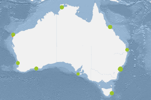
This dataset comprises the measurement of Secchi Depth and Total suspended solids (inorganic and organic components) analysed from samples collected as part of the Integrated Marine Observing Systems (IMOS) National Mooring Network -National Reference Station (NRS) field sampling. Nine Sites are included in the IMOS NRS field sampling stations. Maria Island (TAS), Kangaroo Island (SA), Esperance (WA), Rottnest Island (WA), Ningaloo (WA), Darwin (NT), Yongala (QLD), North Stradbroke Island (QLD) and Port Hacking 100 (NSW). Sampling at these sites is conducted by several members of IMOS NRS Biogeochemical project. Sampling at the sites began between 29/9/2008 and 8/11/2010 and is currently ongoing for 7 sites. Sampling ceased at Ningaloo and Esperance (WA) sites in Aug/Sept 2013. Sampling is conducted monthly (Esperance and Ningaloo were 3 monthly) off small vessels. Depths sampled range from surface to 105 metres depending on the site. Depths are usually sampled at 10 metre intervals. Details including information on station locations, depths sampled and sample types collected are shown in the PDF link below extracted from the IMOS NRS NATIONAL REFERENCE STATIONS BIOGEOCHEMICAL OPERATIONS - A PRACTICAL HANDBOOK, Version 2.2 July 2012. A link to the full handbook is also provided which includes full details of the sampling regime and analyses. Historical data collected as part of CSIRO Coastal Monitoring program is available for three of the National Reference Station sites: Maria Island Coastal Station Data 1944-2008, Port Hacking 100m Coastal Station Data 1953-2010 and Rottnest Island Coastal Station Data 1951-2009. The links to the metadata and access for these data is provided below. Data storage and access is planned to be interoperable with other national and international programs through the IMOS Infrastructure. Station metadata can be found through this resource. Data is available freely via the AODN portal: https://portal.aodn.org.au.
-

This dataset comprises the results of phytoplankton pigment composition analysed from samples collected as part of the Integrated Marine Observing Systems (IMOS) National Mooring Network - National Reference Station (NRS) field sampling. Pigment samples are taken for the complete water column (0-50m) and at the depths of the shallow WQM and the deeper WQM attached to the mooring at that site. Nine Sites are included in the IMOS NRS field sampling stations. Maria Island (TAS), Kangaroo Island (SA), Esperance (WA), Rottnest Island (WA), Ningaloo (WA), Darwin (NT), Yongala (QLD), North Stradbroke Island (QLD) and Port Hacking 100 (NSW). Sampling at these sites is conducted by several members of IMOS NRS Biogeochemical project. Sampling at the sites began between 29/9/2008 and 8/11/2010 and is currently ongoing for 7 sites. Sampling ceased at Ningaloo and Esperance (WA) sites in Aug/Sept 2013. Sampling is conducted monthly (Esperance and Ningaloo were 3 monthly) off small vessels. Depths sampled range from surface to 105 metres depending on the site. Depths are usually sampled at 10 metre intervals. Details including information on station locations, depths sampled and sample types collected are shown in the PDF link below extracted from the IMOS NRS NATIONAL REFERENCE STATIONS BIOGEOCHEMICAL OPERATIONS - A PRACTICAL HANDBOOK, Version 2.2 July 2012. A link to the full handbook is also provided which includes full details of the sampling regime and analyses. Historical data collected as part of CSIRO Coastal Monitoring program is available for three of the National Reference Station sites: Maria Island Coastal Station Data 1944-2008, Port Hacking 100m Coastal Station Data 1953-2010 and Rottnest Island Coastal Station Data 1951-2009. The links to the metadata and access for these data is provided below. Data storage and access is planned to be interoperable with other national and international programs through the IMOS Infrastructure. Station metadata can be found through this resource. Data is freely available through the AODN portal: https://portal.aodn.org.au
-

Zooplankton biomass data have been collected in Australian waters since the 1930s, yet most datasets have been unavailable to the research community. We have searched archives, contacted researchers, and scanned the primary and grey literature to collate this dataset of marine zooplankton biomass from Australian waters, within the geographical extents of 0-60S, 100-160E. Many of these are small-scale datasets , when combined, they provide over 85 years of large-scale zooplankton community biomass data for Australian waters from 1932 to the present. The data have been standardised, erroneous data removed, and all metadata included. We have lodged this dataset with the Australian Ocean Data Network (http://imos.aodn.org.au/), allowing full public access. The Australian Zooplankton Biomass Database will be invaluable for global change studies, research assessing trophic level linkages, and for initialising and assessing biogeochemical and ecosystem models of lower marine trophic levels. A snapshot of the Australian Zooplankton Biomass Database as of early 2020 (2020-04) has been assigned a DOI and will be maintained in perpetuity by the Australian Ocean Data Network (AODN). The ongoing version of this database will be freely available through the AODN Portal (http://portal.aodn.org.au/) in the near future. The relevant dataset at AODN is described here: http://catalogue-rc.aodn.org.au/geonetwork/srv/eng/metadata.show?uuid=64533cd3-0a63-4152-823b-852b1901d6c9 This is the bibliographic reference for the dataset and the AODN metadata record that describes it: McEnnulty FR, Davies CH, Armstrong AO, Atkins N, Coman F, Clementson L, Edgar S, Eriksen RS, Everett JD, Koslow JA, Longborg C, McKinnon AD, Miller M, O’Brien TD, Pausina SA, Uribe-Palomino J, Rochester W, Rothlisberg PC, Slotwinski A, Strzelecki J, Suthers IM, Swadling KM, Tonks ML, van Ruth PD, Young JW, Richardson AJ (2019), The Australian Zooplankton Biomass Database (1932 - 2019). Australian Ocean Data Network - DOI: 10.26198/5c4170d42ab24 (http://dx.doi.org/10.26198/5c4170d42ab24).
-
This dataset contains the results from algal bloom surveys in the Swan River, Perth, Western Australia. Aeroplane flights were used to map the extent of the blooms and at the same time, sea truthing of the images were made using an analysis for various pigments and obtaining phytoplankton samples. Four flight periods were made between October 1994 and December 1995, with up to 4 flights a day. The main species studied was the dinoflagellate Gymnodinium.
-
A study of the scallop resources, advection and settlement of P fumatus in Bass Strait was carried out in Bass Strait and Great Oyster Bay on a series of cruises from 1986 to 1992. Scallop growth and reproduction were also analysed. Vessels used included Merindah Pearl and Dell Richey. Additional data identified in June 2015. See TRIM references in stored data location.
-
This series of twelve, monthly, fish-spotting maps has been prepared from logs of CSIRO fish spotting aircraft, the New South Wales State fisheries aircraft and the Fish Protein Concentrate aircraft based in Tasmania. The CSIRO fish-spotting aircraft was funded by the Fisheries Development Trust Fund.
-
Algal biomass in the Perth region were identified from quadrat surveys , as part of the SRFME research program. The aim of the SRFME Coastal project is to characterize the coastal benthic ecosystems of southwestern WA, with particular focus on benthic reef cosystems, their productivity and dynamics, and the physical, chemical and biological factors driving variability along dominant spatial and temporal scales. To achieve this, we undertook 3-monthly seasonal sampling from 2003 - 2005 at a series of coastal sites situated between Cape Naturaliste in the south and Jurien Bay in the north. Benthic Sampling was integrated with satellite observations of SST, ocean colour and subsurface measurements of other water column properties, as well as sediment biogeochemical sampling. Within this region benthic sampling was nested at Regional (100s km) Local (10s km) and Site (1 km) scales and within each of the regions additional sites were sampled to incorporate site scale variability along cross-shore gradients.
-
Algal biomass in the Rottnest Island region were identified from quadrat surveys , as part of the SRFME research program. The aim of the SRFME Coastal project is to characterize the coastal benthic ecosystems of southwestern WA, with particular focus on benthic reef cosystems, their productivity and dynamics, and the physical, chemical and biological factors driving variability along dominant spatial and temporal scales. To achieve this, we undertook 3-monthly seasonal sampling from 2003 - 2005 at a series of coastal sites situated between Cape Naturaliste in the south and Jurien Bay in the north. Benthic Sampling was integrated with satellite observations of SST, ocean colour and subsurface measurements of other water column properties, as well as sediment biogeochemical sampling. Within this region benthic sampling was nested at Regional (100s km) Local (10s km) and Site (1 km) scales and within each of the regions additional sites were sampled to incorporate site scale variability along cross-shore gradients.
-
Algal biomass in the Jurien Bay region were identified from quadrat surveys as part of the SRFME research program. The aim of the SRFME Coastal project is to characterize the coastal benthic ecosystems of southwestern WA, with particular focus on benthic reef cosystems, their productivity and dynamics, and the physical, chemical and biological factors driving variability along dominant spatial and temporal scales. To achieve this, we undertook 3-monthly seasonal sampling from 2003 - 2005 at a series of coastal sites situated between Cape Naturaliste in the south and Jurien Bay in the north. Benthic Sampling was integrated with satellite observations of SST, ocean colour and subsurface measurements of other water column properties, as well as sediment biogeochemical sampling. Within this region benthic sampling was nested at Regional (100s km) Local (10s km) and Site (1 km) scales and within each of the regions additional sites were sampled to incorporate site scale variability along cross-shore gradients.
